Volcanic history of Olympus Mons
The volcanic history of Olympus Mons spans nearly the entire martian geologic record (Werner et al., 2009), and has been deduced based on crater retention ages of surface units on, and around, the volcano. Crater retention ages provide insight into when the last resurfacing event occurred, and in general, surface units with few craters are relatively young, whereas more heavily cratered units are older. Three main types of deposits are present at Olympus Mons, namely the aureole deposits, lava flow deposits and glacial deposits. Here, we will investigate each of these deposits, as well as the structure of the summit caldera, and relate the observed morphologies to the style of volcanic activity.
Aureole Deposits
The oldest deposits produced by Olympus are a series of stratigraphically separable units, called aureole deposits, that are related to major flank collapse events that occurred >3.8 Ga ago (Hartmann, 2005). Each aureole unit is 0.5 to 1.5 km thick, and the surfaces of the materials display abundant curvilinear ridges and troughs 10 to 100 km long and 1 to 5 km wide, which form an interconnected network of patterns that vary in length and width over the aureole (Morris, 1982).
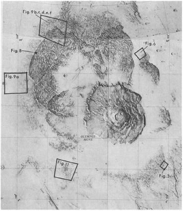
Figure 6. Viking orbiter image showing the spatial extent of the aureole deposit that extends to the northwest of Olympus. Taken from Morris, (1982).
Reasons for the collapse of Olympus Mons during the early history of Mars revolve around the idea of having a weak basal layer beneath Olympus Mons (McGovern and Morgan, 2009). One hypothesis is that erosion, and production of phyllosilicate layers several hundreds of meters thick may have been present in the location of the future Olympus Mons, and that lava flows were emplaced directly on top of these sheet silicates (McGovern and Morgan, 2009). After sufficient build up of the volcano, the volcano may have collapsed radially producing the observed aureole deposits (Morris, 1982).
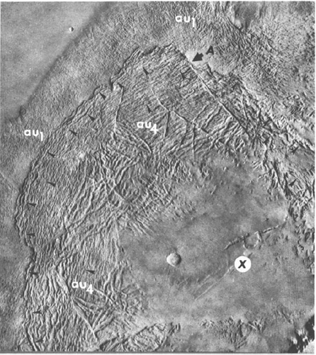
Figure 7. Aureole deposit showing the grooved terrain and the superposition relationship between the stratigraphically lower unit au1 and the upper unit, au4. The 'x' marks an inferred volcanic vent that could have produced the aureole deposit. This image is taken from Morris, (1982).
Additional, smaller scale landslide events are observed along the edges of the volcanic edifice of Olympus Mons. Collapse deposits along the steep, 10-km high escarpment bear similarity to the aureole deposits, and also have similar crater retention ages of ~3.8 Ga (Neukum et al., 2004). The steep escarpment is likely associated with the landslide events that produced the Aureole.
Based on the old age of the expansive aureole deposit, and the inference that the deposit was produced as a direct result of flank collapse, Olympus Mons must have had been built up early in the history of Mars to create an instability along the flanks (Werner, 2009). This notion is supported by crater retention ages of the other shield volcanoes in the Tharsis province, which also have ages ~3.8 Ga on the present-day slopes (Werner, 2009).
Based on the old age of the expansive aureole deposit, and the inference that the deposit was produced as a direct result of flank collapse, Olympus Mons must have had been built up early in the history of Mars to create an instability along the flanks (Werner, 2009). This notion is supported by crater retention ages of the other shield volcanoes in the Tharsis province, which also have ages ~3.8 Ga on the present-day slopes (Werner, 2009).
Lava Flow Deposits
Crater retention ages of lava flow deposits on the flanks of Olympus Mons range in age from 700 Ma (Werner, 2009) to as recently as 4 Ma on the lowest flanks of the volcano (Neukum et al., 2004). The most recent geologic mapping of Olympus mons was conducted by Bleacher et al., (2007). While the study area is limited by the spatial extent of available imagery at the time of publication, Bleacher et al., (2007) identified several different types of surface units and made observations of cross-cutting relationships where present. In their study, Bleacher et al., (2007) determined that tube-fed flows are commonly cross-cut by channel-fed flows. On the basis of Hawaiian analogues, where the style of volcanism is related to the longevity of the eruptive episode, Bleacher et al., (2007) proposes that longer lived, stable tube forming eruptions were followed by a transition to shorter-lived, less stable, channel forming eruptions.
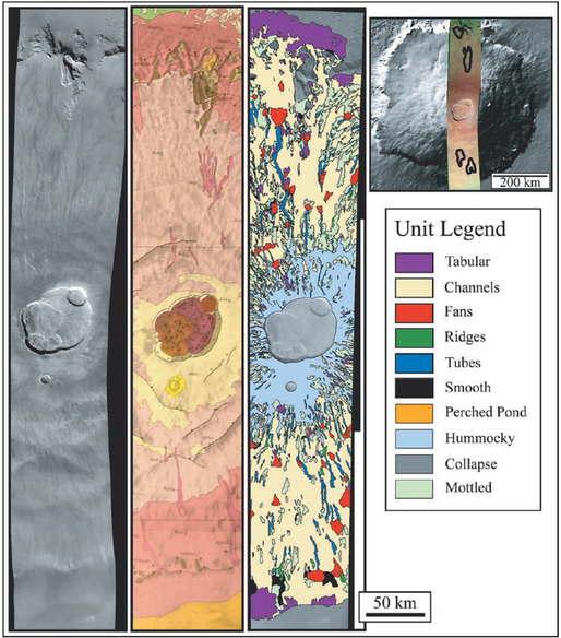
Figure 8. High Resolution Stereo Camera (HRSC) image H0037 covering Olympus Mons is shown (left strip) along with a corresponding portion of the geologic map of Morris and Tanaka, (1994) (middle strip) and the lava flow map produced by Bleacher et al., (2007). This figure is taken from Bleacher et al., (2007).
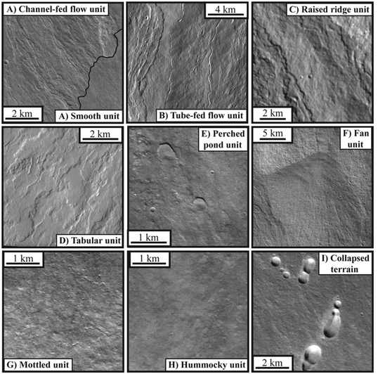
Figure 9. Type examples of map units named in Figure 8 by Bleacher et al., (2007). Image is taken from Bleacher et al., (2007).
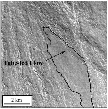
Figure 9. HRSC image H0037 showing the typical relationship between lava channels and tubes on Olympus Mons, as mapped by Bleacher et al., (2007). In the above image, the older tube-fed flows are embayed by the younger channel-fed flows. This image is taken directly from Bleacher et al., (2007).
Prior to the publication of Bleacher et al., (2007), geologic mapping was conducted on 130 - 200 m/pixel Viking images that were collected between 1976 and 1980 (Scott and Tanaka, 1986; Morris and Tanaka, 1994). These global maps provided context for interpreting the broad-scale surface geology of Mars, and permitted the distinction of surface units that embay, and are in direct association with, Olympus Mons.
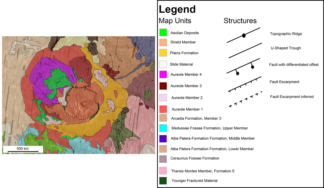
Figure 10. Geologic map published by Scott and Tanaka, (1986) shows Olympus Mons mapped as one unit (shield member). A plains formation embays Olympus Mons to the south and east (in orange), and four members of aureole units emanate outwards from the northwestern flank of the volcano. Regional structures are acknowledged as either ridged units, or faults with differentiated offset.
The Olympus Mons Caldera
At the summit of Olympus Mons are six nested calderas that each record morphologies indicative of the mode of emplacement. The caldera cluster is approximatley 60 km x 85 kilometers in diameter. Each caldera is thought to have formed as a result of an initial effusion (Hawaiian style) of low-viscosity basaltic lava, and the eventual ponding of lava directly above the underlying magma reservoir. Due to lateral migration of the underlying magma body, the caldera collapsed to form the 0.5 km to 3 km deep calderas (Wilson et al., 2001). The lobate appearance of the lava flows is noted in some places on the caldera floors, and typically does not drape over the nested caldera walls. The collapse depression may have formed long after the eruption of lava to the surface (Mouginis-Mark and Robinson, 1992).
The two smallest calderas, shown with roman numerals II and V in the bottom left of Figure 10, have flat floors, and do not display any structural deformation after the collapse event. The remaining calderas, however, show evidence for extension (grabens), and compression (wrinkle ridges). In Figure 10, the grabens appear circumferential in crater I. Wrinkle ridges are features associated with compression, due to the contraction of lava and/or thrust faulting. The ridges are present in craters I, III and IV, and indicate that structural deformation was accomodated during the formation (or sometime after) the collapse that resulted in the numerous caldera.
Crater retention age dating has been applied to the several calderas to identify the most recent resurfacing event. The age dates average about 150 Ma, which coincides with the ages of some lava flow deposits at the base of the Olympus Mons flank.
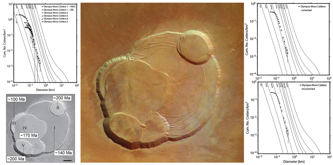
Figure 11. The caldera of Olympus Mons. The lower left inset shows results of caldera age determination from Neukum et al., (2004). All crater counts applied to the caldera floors appear to cluster at about 150 Ma. However, based on morphology alone, the calculated age dates provide erroneous dates to the true sequence of events. As described by Mouginis-Mark, (1981), the oldest crater should be crater I, and the youngest, crater V; a sequence which is not portrayed by the crater retention age dates in the lower left hand image of this figure. This image is taken from Werner, (2009).
Glacial Deposits and Isolated Volcanism
Some of the most recent activity at Olympus Mons has consisted of glacial, fluvial, and some volcanic activity on the outskirts of the eastern, and western Olympus Mons escarpment. Glacial activity is found on the western scarp (Neukum et al., 2004; Milkovich et al., 2006), while dike intrusion, and fluvial network formation is found on the east (Basilevsky et al., 2006).
Glacial deposits were first identified as landslide deposits by Morris and Tanaka, (1986), but with the advent of higher resolution imagery in the past ten years (with resolutions better than 10 m/pixel), a more accurate assessment has revealed that these morphologic units appear to be dust-covered glaciers (Milkovich et al., 2006). The youngest crater retention age of these units is 4 Ma (Neukum et al., 2004), and the majority of the glacial surfaces range in age from 130 Ma to 280 Ma (Neukum et al., 2004).
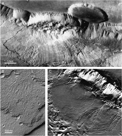
Figure 15. Examples of martian lobate deposits representing different candidate formation mechanisms. (A) Landslide in Ganges Chasma, Valles Marineri. Take notice of the radial grooved texture of the debris apron. (B) Lava flow in Daedalia Planum. Note the blocky flow texture and irregular flow margins. (C) Debris-covered glacial lobe at the base of the western Olympus Mons scarp. The glacial mechanism of formation is favored by Neukum et al., (2004), and Milkovich et al., (2006). This image is taken from Milkovich et al., (2006).
At the base of the eastern escarpment, a different regime of activity has taken place. Dike intrusion at the base of the eastern Olympus Mons scarp is thought to have melted a cryosphere, or ground- or surface- ice, and melted large quantities of water which then carved out many channels. The fluvial features produced are similar to those elsewhere on Mars, and the close association of the dikes and the channels makes the authors believe that they are, in fact, related phenomenon. Crater retention age dates of the channel floors indicates that the channels are very recent, between <= 25 to 40 Myr.
Similar episodes of volcanic activity are proposed for the northern flank of Olympus, where dikes intruded into a cryosphere to produce phreatomagmatic eruptions. These magmatic dikes are thought to be related to Olympus and could be related to the stress field generated by the large shield volcano.
Similar episodes of volcanic activity are proposed for the northern flank of Olympus, where dikes intruded into a cryosphere to produce phreatomagmatic eruptions. These magmatic dikes are thought to be related to Olympus and could be related to the stress field generated by the large shield volcano.
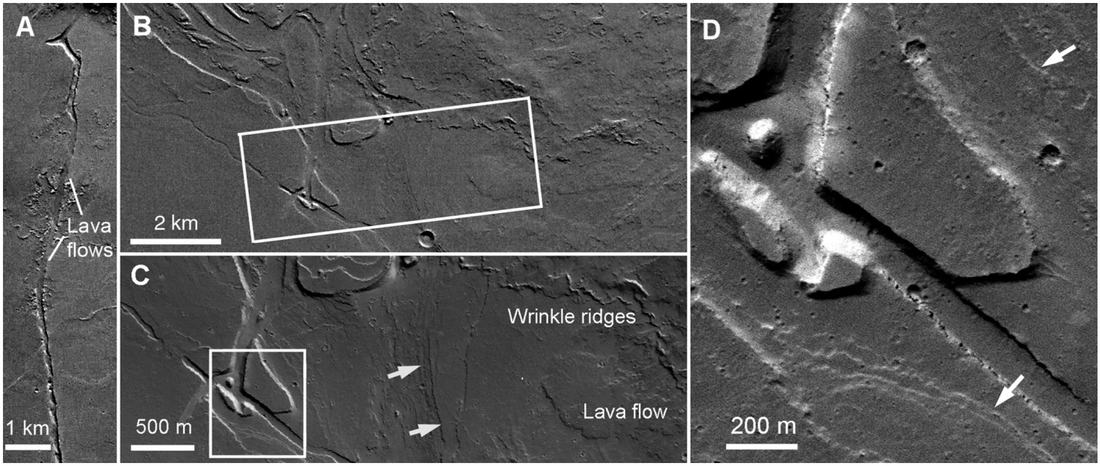
Figure 16. Parts of the channel network in the lowland plains east of the Olympus Mons escarpment. Arrows show the erosional terraces that are associated with erosive episodes. This panel of images is taken from Basilevsky et al., (2006).
Geochemistry and Explosive Eruptions
Currently, there are spectrometers in orbit around Mars that can detect surface mineralogy. These instruments are very sensitive to dust and only 1/1000 of an inch will mask the mineralogy of the surface. Unfortunately, the Olympus Mons region is dust covered, and there have been no published attempts at quantifying the spatial variation in surface mineralogy on the volcano. The surface geochemistry of Olympus Mons is likely basaltic, based on the observed morphology and inferred eruptive style at Olympus Mons.
Explosive eruptions at Olympus Mons are not discussed in the scientific literature. Some authors (Wilson and Head, 2007; Glaze et al., 2011; Kerber et al., 2012) have modeled the dispersal of ash, and theorized that basaltic plinian plumes would attain a level of neutral buoyancy of 20 km altitude. The science of investigating the basaltic plinian eruptions (since volcanic activity on Mars is predominantly basaltic), are still in their infancy and I did not report on them because no such model is applied for the type of eruption that occurred at Olympus Mons.
